📷 Pamir Highway. Part 1. From Kyrgyzstan to Tajikistan

Before talking about a recent trip to Kyrgyzstan, I decided to share with you a story about my first acquaintance with this country. It was a few years ago, and the main part of the trip fell on Tajikistan — we made a trip along the Pamir Highway, it started from Kyrgyzstan and ended there.
In general, our route looked something like this:

That is, we traveled through Kyrgyzstan to Tajikistan and back. About Tajikistan and the Pamir Highway will be in the following posts, and today — about the beginning of that journey and first views of Kyrgyzstan.
In September 2017, I joined a group of travelers planning to drive expedition jeeps along the Pamir Highway. Before that, I planned all my travels on my own: I bought tickets, booked hotels, read about the country, trying to look through a lot of other people's reports — remember the nuances, write out interesting places and identify possible difficulties. I built the route and tried to stick to it as accurately as possible, and I always more or less imagined where I would be tomorrow.
But that time it was absolutely not like that! The organizer of author's tours Dmitry Kozlov invited me after he saw my post about a trip to Iceland. In his group there were a couple of empty seats, and he decided to invite photographers who would try to convey the beauty of the surrounding nature. The trip was completely prepared by him, and I was just getting ready to look around and be surprised. So I suddenly found myself on the way to the Pamir Highway, met, and then became friends with Dmitry, and subsequently traveled with him to several more countries. And now he lives here in Kyrgyzstan, organizes mini-tours and larger expeditions in this country, and is just now opening his own glamping. Life is an amazing thing!

I love mountains, I love to travel, but there is one problem: I don’t know geography very well and I can’t always say exactly where this or that place is located. Of course, I heard about the Pamir, and with it — about Communism Peak and Lenin Peak. But where are they? I couldn't remember right off the bat, so I had to open the map. I was amazed: Communism Peak is in Tajikistan, Lenin Peak is on the border of Kyrgyzstan and Tajikistan. In the days of the Soviet Union, they were called like that, and still in many Russian-language (and not only) sources they are called in this old way, but in general, they now have other official names: Ismoil Somoni Peak and Ibn Sina Peak.
So, I was going to Central Asia! To be honest, I thought that I would not get to this region soon. My childhood was spent in Uzbekistan, another Central Asian country, where my grandparents lived. My parents sent me to them for three years while my father worked in Chukotka, and later I spent every summer with them. So I love Central Asian cuisine very much and I am completely calm about the heat. When the USSR collapsed, most of my relatives left Uzbekistan, but I always had a desire to return and see how everything was there.

What do I remember from that period of my childhood? Of course, watermelons and melons, bazaars and the Syrdarya River, endless plains, ditches and cotton fields. But I don't remember the mountains. I love to learn new things and never get tired of looking around, so any opportunity to visit another country is a great joy for me. And also there, on the Pamir Highway, we could look across the border at Afghanistan, where my great-uncle was a military adviser at one time. Although I have never been to Kyrgyzstan or Tajikistan before, I was sure that the trip would be interesting.
And so, our plane was flying over the lifeless yellow-brown desert, among the hills and dunes one can see dusty roads and rare buildings... This is approximately how I imagined Kyrgyzstan, where our journey was supposed to start from.

But when the flight attendant said that we were descending, and the plane began to circle before landing, the water surface of the Ala-Archa reservoir and many green fields appeared in the window. A real oasis opened up to our eyes. How much strength and hard work is needed to grow all this greenery!
We landed at the airport in Bishkek, the hot and very green capital of Kyrgyzstan. The Bishkek Manas airport has a strange abbreviation — FRU. And all because earlier, in Soviet times, the city was called Frunze, in honor of the chairman of the revolutionary military council, Mikhail Frunze.
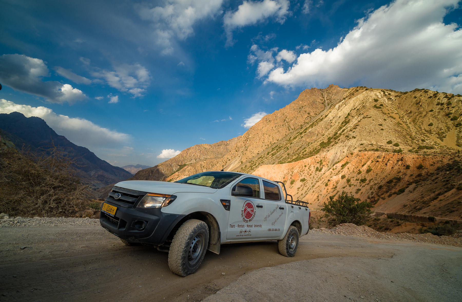
In Bishkek, it is easier than in Tajikistan to rent a car. That is why we started our journey there. Rented off-road cars from Iron Horse Nomads company.

Renting an expeditionary prepared car now costs about $100 or more per day on average. And there is something to prepare for: some sections of the road on the Pamir Highway have not been repaired since the time of the USSR. And the road is also very dusty, sometimes drivers had to drive almost blindly, because due to the dust raised by the previous car, it was almost impossible to see ahead, and our small caravan of 4 cars had to increase the gaps between cars in order to reduce dust.
In general, I got acquainted with the local driving style in a taxi from the airport. The driver really liked to drive right in the middle of the road, and he began to overtake, even if there was oncoming traffic. An oncoming car in such situations on a narrow road began to drive almost along the side of the road. Strangely, similar situations were repeated many times, but they passed in a very calm mode — no beeps and no swearing. As if it should be!
By the way, there is a wonderful cafe "Faiza" in Bishkek. If you're nearby, be sure to go there. It is not easy to find a free place in it, because a lot of locals like to dine there, and this is always an indicator of quality. Manti with pumpkin, pilaf and shorba were wonderful 6 years ago, and they are still wonderful this year, I checked it not so long ago :)
The next morning, after spending the night in Bishkek, our automobile caravan set off towards adventure.
 |  |
|---|
The road ran through pastures, on which there were real yurts. The Kirghiz put them up and live here for several months with the whole big family during the warm season. It’s a pity, but we didn’t have time to stop, get to know them and go inside. In the first days of the trip, we looked around mainly from the windows of jeeps, because it was not close to the main goal of our trip, the Pamir Highway.

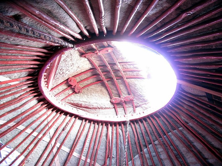
Part of the yurt, the tunduk, is even depicted on the flag of Kyrgyzstan. Tunduk or shanyrak is a cross, the intersection of lines inscribed in a circle — the opening in the center of the roof of a yurt. It supports the walls and smoke from the fire comes out through it. Tundyuk is a symbol of hospitality and unity of all nationalities living in Kyrgyzstan.
 |  |
|---|---|
| Image Source: | Wiki |
Standing like this, in the foothills or in the valleys between the mountains, the yurts look very picturesque.

On the road in these places you can often see sellers of something like small white balls. It qurut, which is a dry, sour-salty cheese rolled into balls. A rather unusual snack for beer or an addition to soups.
Here you can also buy kumis, a low-alcohol drink made from mares' milk. It is believed that it helps with various diseases of the digestive system and tuberculosis, and for these purposes it is necessary to drink it in a course.
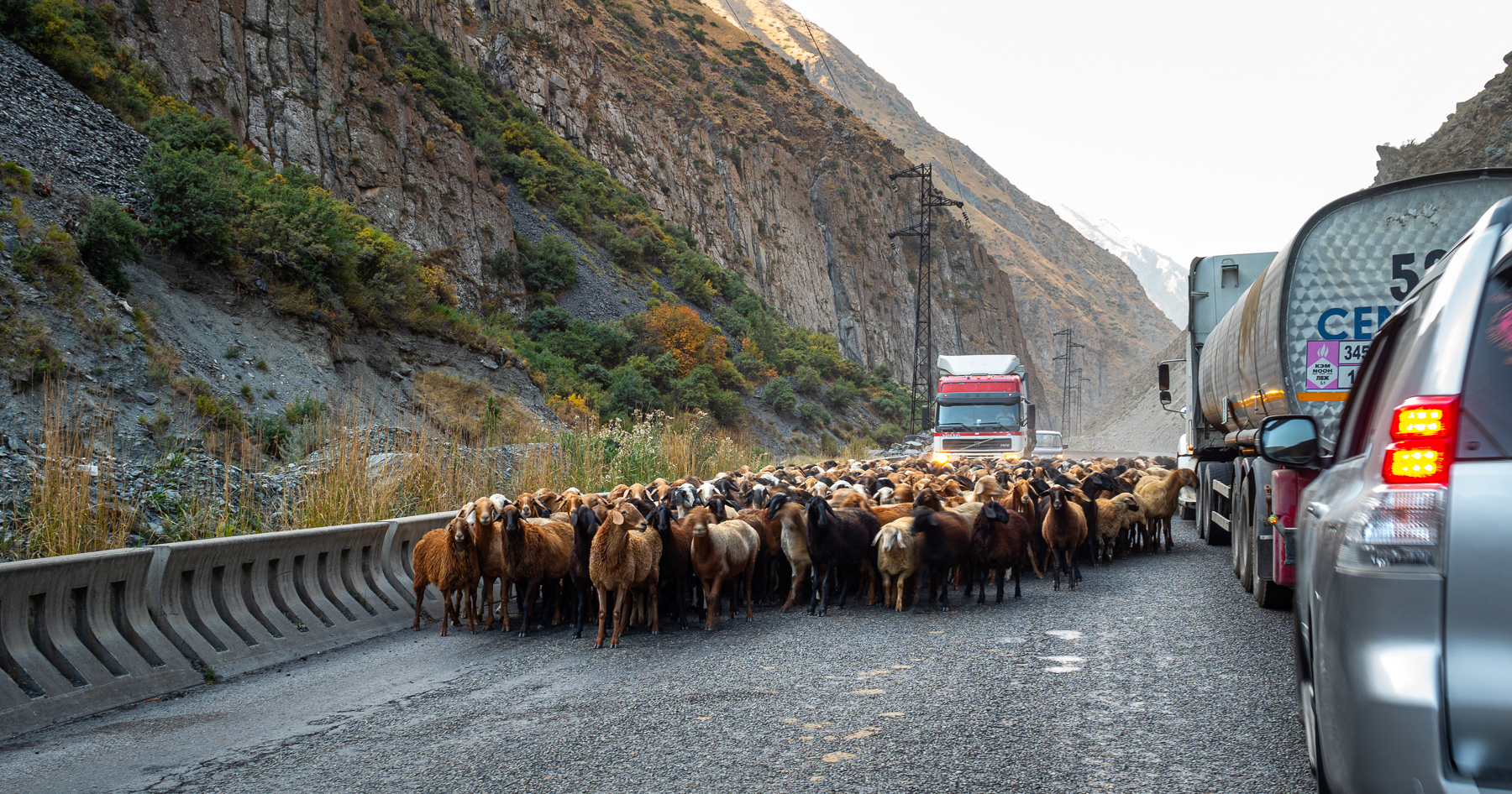
From time to time herds of sheep blocked the road. Then the speed of movement fell and we moved very slowly. In this photo we met them among the rocks of the Kara-Balta gorge.
Chychkan Gorge.
 |  |
|---|
We climbed higher and higher. Soon there will be Töö Ashuu Tunnel, and the main thing is to get there before the cattle are led through it. Then the tunnel is closed to the passage of cars, because it is quite narrow and there is no ventilation in it. Two and a half kilometers in exhaust gases can lead to bad consequences for both people and animals.

We drove along the roads lit by the bright sun, looked around and looked forward to adventure. It was hot and happy.

One of the overnight stays took place in the city of Osh, the second-largest and the oldest city in Kyrgyzstan which is located around the Sulayman Mountain. It is said that it was here that the prophet Solomon conducted his conversations with God. And thanks to this, water appeared in the district — the Ak-Buura River. Now the mountain is under the protection of UNESCO, and they say that Solomon's body prints are still visible there!
By the way, Osh is very close to Uzbekistan. The distance from the Sulayman Mountain to the border is about five kilometers, but we were not going there, just further along Kyrgyzstan, towards Tajikistan.

We decided to make a small detour and look at the Papan reservoir, located southeast of Osh. It was about twenty kilometers to go.

The Ak-Buura River, locked in the Papan Gorge. Ak-Buura means "white camel".

And this is a view in the opposite direction to the road along which we drove. And somewhere in the grass, by the side of the road, I lost the pegs from the takeoff field for my drone, which I then used. It was not the last loss on that trip :)

Once in Iceland, I had to travel rather far from the city to see the colored mountains, and what was my surprise when in Kyrgyzstan we went to the Toktogul reservoir and I saw this landscape. I just demanded a photo-stop, because it was beyond my strength to drive by! Fortunately, everyone wanted to stop and rest, enjoy the view and swim.


Yellow-red mountains reflected in the blue water and gleamed in the sun. Surprisingly, in such a beautiful place, I did not see any prepared places for recreation. No beaches, no tourists. We were the only ones who swam on the long coast of the largest reservoir in Central Asia. Very well :)

Near the road there was a cafe, the main attraction of which is a swing with a beautiful view of the reservoir, standing on a cliff. You don't want to get up from them.

The Naryn River, on which the Toktogul Dam is built, has made its way through the gorge and the water in it has an amazing color. The length of the river is about eight hundred kilometers, its source is on the Tien Shan glaciers, and in Uzbekistan it turns into the Syr Darya River.

Several hydroelectric power stationы have been built on the river. This photo shows the Kürpsay Dam located downstream of the Toktogul HPP.

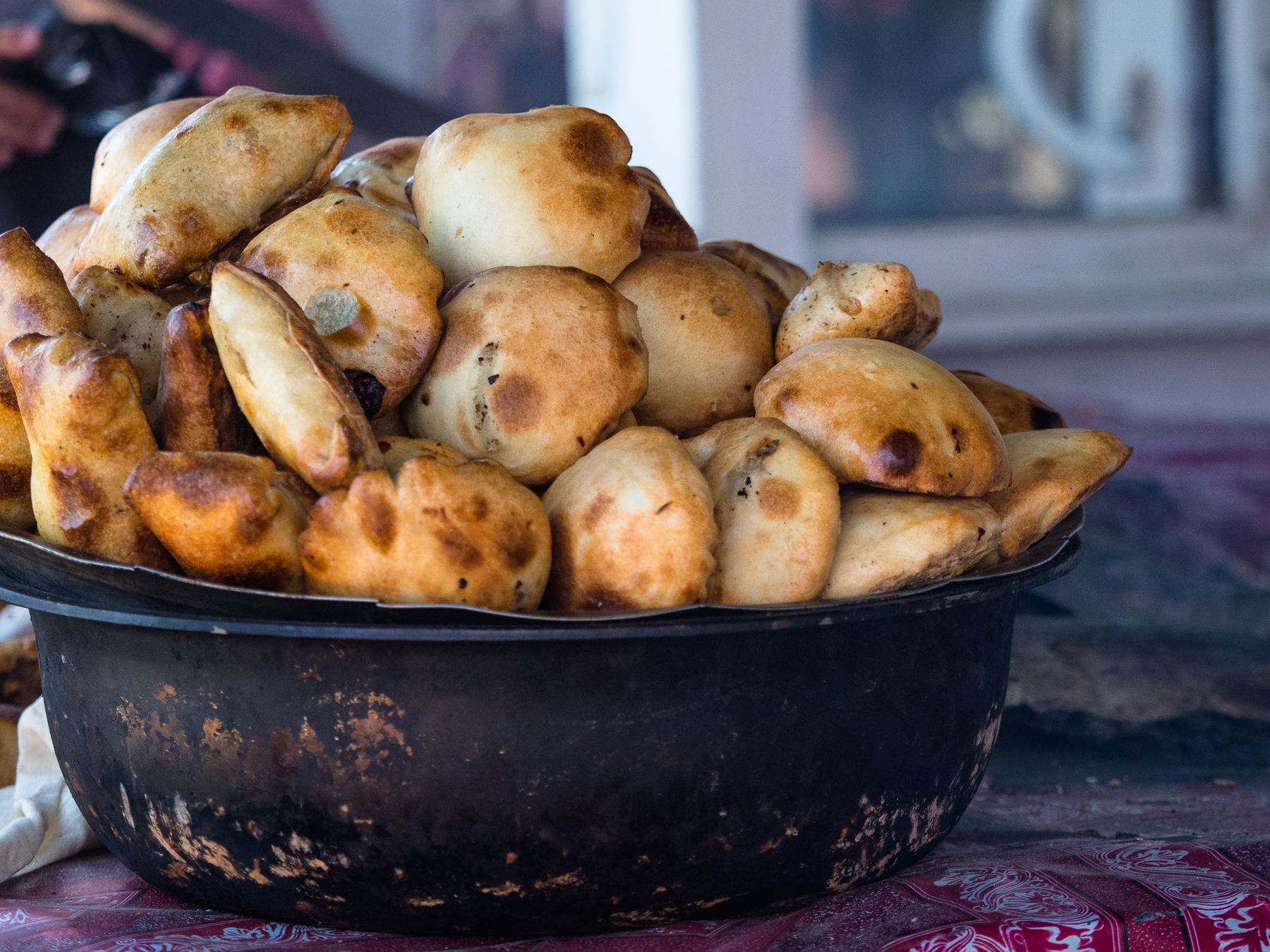
Well, we have approached the border with Tajikistan! After all the beauties of the road, we stopped at the bazaar and ate delicious tandoor piping hot samsa, and kebab, and only then entered a new country. After all, it is not known how much time we would have spent at the border. We sat there for about two and a half hours, waited for paperwork and ate watermelon right under the windows of the border guards.
Then there was Tajikistan, alpine lakes, yaks and completely different, but no less amazing landscapes, which I will show later.
Well, since today we are talking about Kyrgyzstan, I continue this post with some photos that I took on the way back, when our trip was almost over.
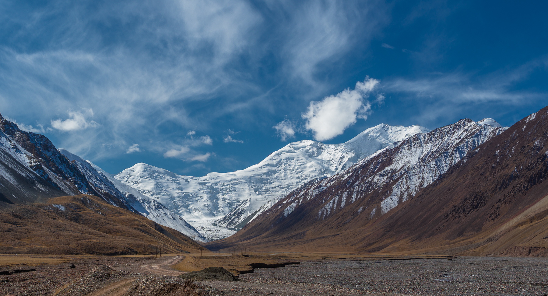
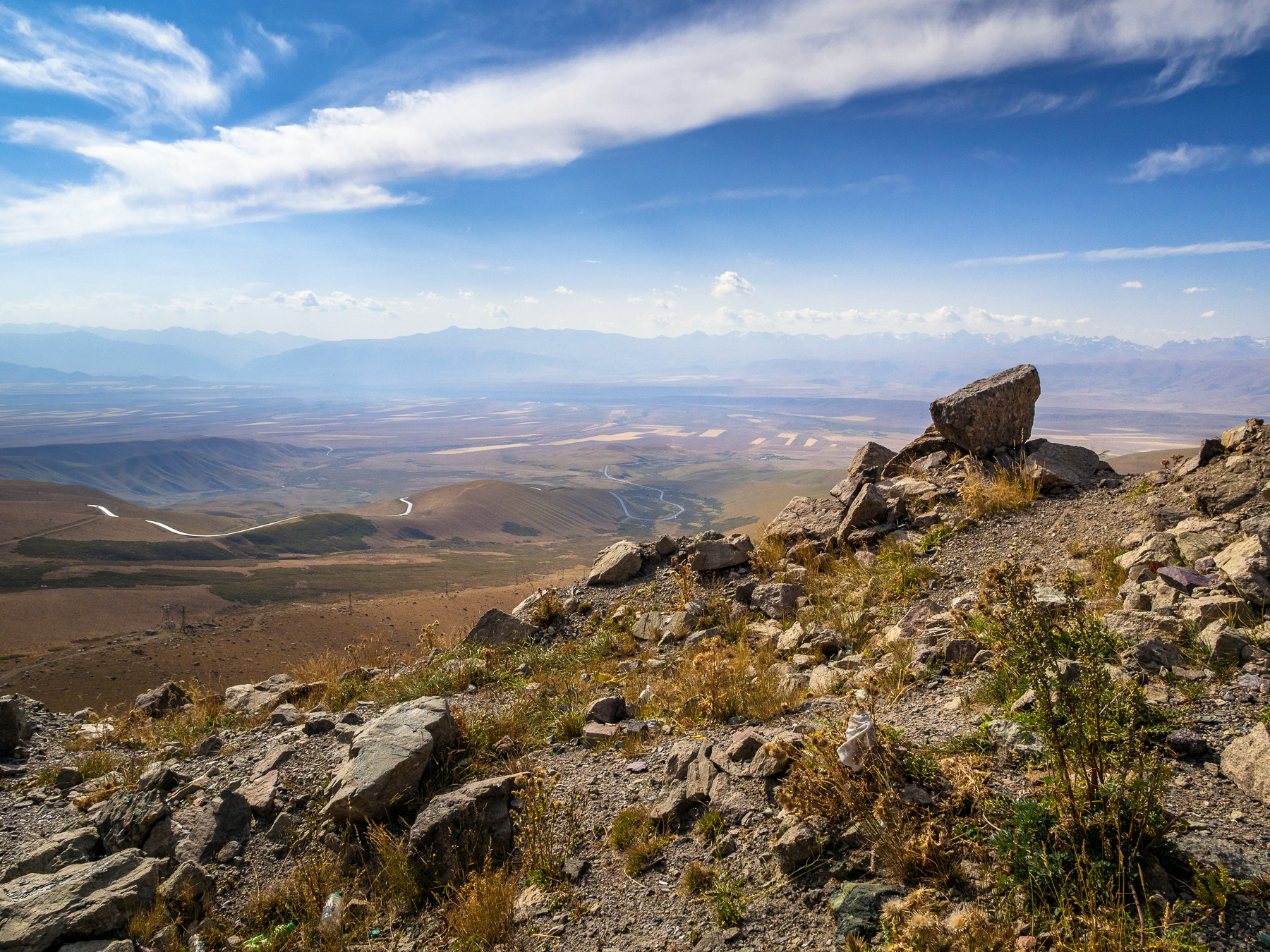
The snow-covered wall of mountains in the distance is the Pamir, and the Alay Valley stretches around.

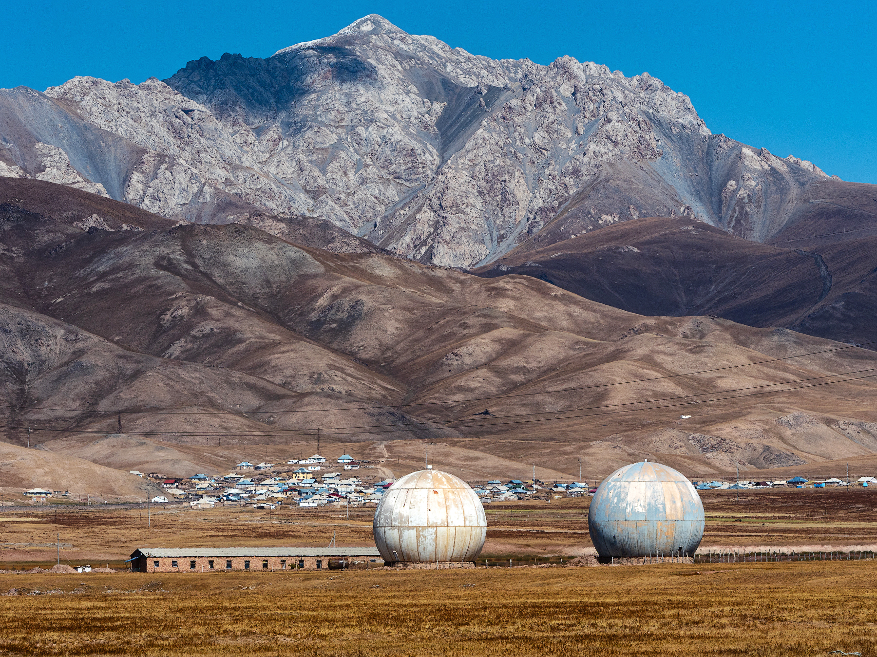
Sary-Tash village. What amazing giant spherical structures! Could this be a UFO landing site? :) Maybe the pilots of these starships have assimilated and built a cafe, and the paint is gradually peeling off their ships due to bad weather, but they don’t need space anymore, because they can see it great here from the plain...
Entering the Gulcha river valley. Do you know what I was thinking about all the time? How nice it would be to come here at sunset!

Such a terrain is called "badlands". These clay hills are very beautiful, but nothing grows there at all and there are often mudflows — mud streams flowing down from the mountains during inclement weather.

By the way, sunsets in Kyrgyzstan are beautiful. Like this one:

Or this one...

And sometimes — sunsets like this. This is the Suusamyr valley. There are many pastures there, because in summer it is all covered with lush grass.

So, after short acquaintance, I realized that Kyrgyzstan is a beautiful country, which you just need to allocate more time to calmly travel along endless roads, walk along mountain paths and see how nature transforms at sunset. That time, back in 2017, I saw this country for the first time and wanted to return one day... And I did. But more about that another time.
To be continued: see you in Tajikistan, on the Pamir Highway.
Camera: OLYMPUS E-M1 Mark II, DJI Mavic Pro
It's better to watch photos in high resolution.
You can also see my photos in my blog LJ and in my profile on RTraveler. You also can read a short interview with me here.

Congratulations, your post has been added to Pinmapple! 🎉🥳🍍
Did you know you have your own profile map?
And every post has their own map too!
Want to have your post on the map too?
Really amazing shots!
Some of them almost look like paintings!
I didn't know Kyrgyzstan nor Tajikistan were so beautiful.
Thanks for sharing.
Thank you!
And we just drove quickly through Kyrgyzstan in one direction and back, and there is a lot to see if you go there purposefully :)
This post has been manually curated by @steemflow from Indiaunited community. Join us on our Discord Server.
Do you know that you can earn a passive income by delegating to @indiaunited. We share more than 100 % of the curation rewards with the delegators in the form of IUC tokens. HP delegators and IUC token holders also get upto 20% additional vote weight.
Here are some handy links for delegations: 100HP, 250HP, 500HP, 1000HP.
100% of the rewards from this comment goes to the curator for their manual curation efforts. Please encourage the curator @steemflow by upvoting this comment and support the community by voting the posts made by @indiaunited.
Thank you for the support!
What an incredible post O.O Woooow!!! This makes me want to go there as soon as possible!
Great work!
Thank you! This is really a good country for traveling - great natural views, reasonable prices, delicious food. So don't delay :)
Amazing photos. Thanks for introducing to Kyrgyzstan.
Thank you very much! If you are interested in more views of Kyrgyzstan, check out a couple of my previous posts, there are recent photos from here. And of course there will be more later :)
Wow, those mountains were amazing! I envy you! 😍
I completely agree with you, the mountains are beautiful! Thank you :)
You have really taken time to explain your sojourn to this Tajikistan. I haven't been there but your pictures says a lot already about the place.
So far, there were only views of Kyrgyzstan in this post, Tajikistan and the Pamir Highway will be a little later :) Glad you liked it!
Wow! I listened to the whole post. So interesting. Thanks for sharing so much info about these countries I know little about and those pictures, especially of the yellow-red mountains. Incredible. Looking forward to more posts!
Oh, did you listen to the text? I haven't fully figured out this function yet, I can't find how to stop audio when I close the window of a post that I started listening to but then turned off. I have to close the tab in the browser.
Thank you, I'm glad you found it interesting! There are so many countries in the world, I often read and stare at stories about those where I have not been yet.
Hiya, @LivingUKTaiwan here, just swinging by to let you know that this post made it into our Top 3 in Daily Travel Digest #1970.
Your post has been manually curated by the @pinmapple team. If you like what we're doing, please drop by to check out all the rest of today's great posts and consider supporting other authors like yourself and us so we can keep the project going!
Become part of our travel community:
Thanks a lot @LivingUKTaiwan!
This place is so beautiful 😍 . I keep wowing in every single shot . There's no ugly angle..all spots are stunning.. Your photos are perfect for wallpapers hehe.
Oh yes, beautiful places, I really like these mountains :) Thank you!
Congratulations @sharker! You have completed the following achievement on the Hive blockchain And have been rewarded with New badge(s)
Your next target is to reach 150000 upvotes.
You can view your badges on your board and compare yourself to others in the Ranking
If you no longer want to receive notifications, reply to this comment with the word
STOPCheck out our last posts:
Потрясающие фотографии! Браво!😊 Величие и просторы природы. Отличное путешествие.
Спасибо большое :)
Да, это путешествие было для меня отличным и необычным по формату, мне очень понравилось тогда!
When I was a child I had a cardboard globe I spent hours spinning and wondering about the places where my finger stopped it. I remember particularly feeling the exoticness of the Syr Darya and Amu Darya. Later I learned of the conquest of the Mongols, and how that impacted this region.
Today I am old, and my childhood wonder was never sated by a wander that way. I think I would have never seen these places but for your travels, pictures, and post, that has reminded me of my childhood awe that such places existed.
Thanks!
Oh, I know this feeling of great curiosity and interest in the world and places in it! That is what pushes me to travel as much as I can.
Yes, this region really has a rich and interesting history. I am glad that my post and photos brought you some fun and memories of your childhood. That's great to hear, thanks!