Долина мамутів | Mammoth Valley [UA/EN]
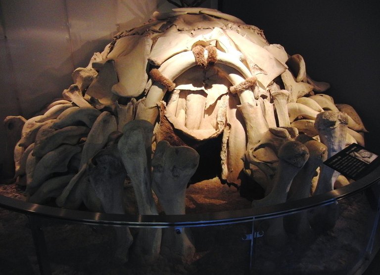
Там де зустрічаються ріки Рось та Росава, знаходиться мальовниче село Межиріч. Перші спогади про це село датуються XVIII століттям, а от люди в цих місцях жили вже в часи пізнього палеоліту. Є тут й знахідки інших часів як то трипільської, зарубинецької та черняхівської культур, а також і періоду Київської Русі. Проте, наша цікавість та мета поїздки була викликана саме палеолітом та тим, що це село здобуло всесвітню відомість знахідкою житла мисливців на мамонтів. У 1965 році місцевий житель Микола Новицький копав льох на території своєї садиби та під час цього заняття відкопав незрозумілу кістку, яку вирішив показати вчителю місцевої школи, а той вже повідомив в Інститут зоології АН УРСР. Цією кісткою виявилася нижня щелепа мамонта. Пізніше, протягом декількох років, науковці провели тут розкопки та віднайшли чотири житла зроблених з кісток мамута.
 |
|---|
| Реконструкція Межиріцької стоянки в Японії (джерело) |
Отже, ми запланували тоді проїхатися три дні, першим із яких мав на меті відвідати місцевість, а точніше долину річки Рось, де в ті часи паслися ці велетні. Я виїхав дуже рано та помчався у напрямку села Межиріч, де за планом було зустрітися з товаришем, який погодився скласти компанію у цій подорожі. За планом у нас було проїхатися від села по правому березі річки Рось, та оглянути тутешню місцевість. Ми вже бували тут влітку, але проїхалися лівим берегом. Лівий берег я знав добре, тому як часто їздив тією дорогою під час подорожей до міста Корсунь. Хоча й не підозрював які тут красиві місця, якщо проїхатися ближче до річки, виїхавши при цьому на заплаву.
 |
|---|
| Пам'ятник «Перемога праці» |
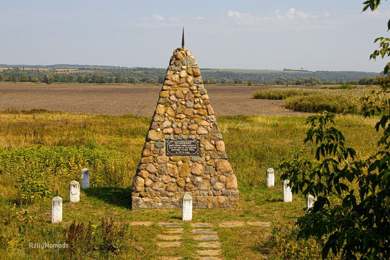
Нам потрібно було проїхатися через все село, проїхати по мосту над річкою й таким чином потрапити на її правий берег, що ми й зробили. За мостом ми під'їхали до пам'ятника, який має назву "Перемога праці". На табличці пам'ятника написано "Збудовано жителями навколишніх сіл на честь осушення заплави річки Рось в 1914 році", а сам він для тих, хто знає історію цих місць, нагадує про катастрофічні події, які відбулися у цих місцях понад сто років тому. В 17 столітті виник великий попит на поташ (карбонат натрію), для виготовлення якого потрібна була велика кількість деревини, через що нещадно вирубувалися ліси. Це призвело до неймовірного розвитку ерозії, не дарма неподалік цього місця знаходиться найдовший яр у Європі - Хмільнянський, та найглибший - Костянецький. У 1903 році Хмільнянським яром прокотився величезний селевий потік, який зніс частину села Хмільна та повністю перегородив ріку Рось, яка через це змила село Михайлівка. До 1911 року тут працювали землечерпалки, щоб прорізати нове річище для Росі. А загалом меліоративні роботи відбувалися тут до 1914 року.
 |
|---|
| На місточку біля села Лука |
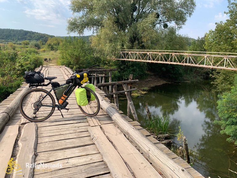
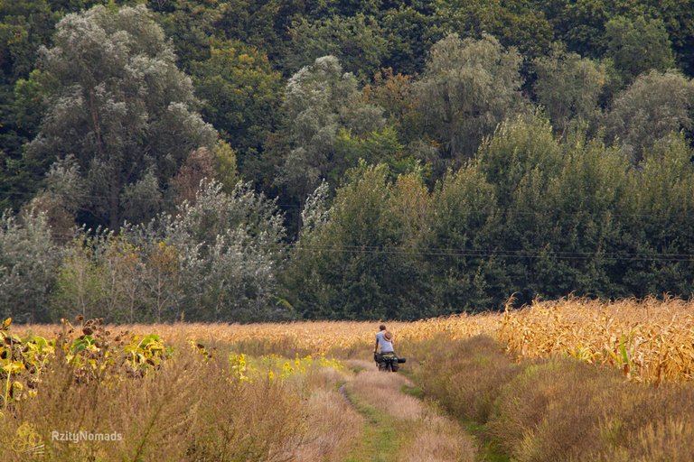
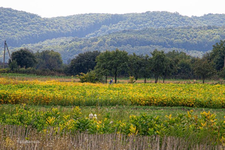
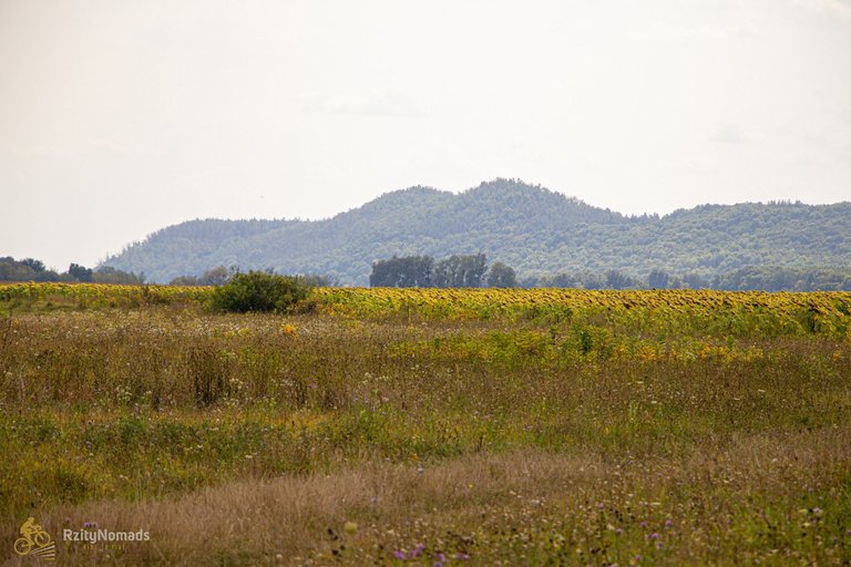
Трохи далі ми звернули з траси та поїхали по правому березі. Але проїхали ми не так вже й далеко - цей берег весь піщаний і нам приходилося переважну частину просто котити велосипеди. Тому ми прийняли рішення у такому режимі пройтися до найближчого містка, переїхати на лівий берег, там проїхати частину шляху, та потім знову повернутися на правий. Що ми й зробили, зрештою діставшись до потрібного нам місця, хоча й не без пригод. У цій місцевості мапа не дуже відповідає дійсності, тому ми заїхали, так би мовити, у тупик. Повертатися назад не було часу, а тому вирішили пропхатися через поле соняхів, потім через височенну траву і якусь ще кабанячу калабаню. А потім ще трішки та прибули на заплановане місце таборування.
 |
|---|
| Ранковий пейзаж |
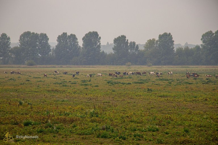
Якось охопити всю цю місцевість, або ж якусь її частину - мені так досі й не вдалося. Влітку ми приїжджали сюди та підіймалися на гору Дівиця в надії, що сфотографуємо місцеві краєвиди, але на її вершині так все заросло акацією, що не можливо нічого розгледіти через ці зарості. Цього ж разу ми знаходилися на нижчому березі, а моєю ідеєю було пофотографувати вранці ранкові тумани. Проте, вночі був дощ, а тому на ранок ніякого туману не було. Тому пофотографував корів, які паслися неподалік - колись тут паслися мамонти, а зараз корови.
 |
|---|
| Їдемо полями |
Далі у нас за планом було оглянути річку Вільшанка від села Старосілля та до того місця, де вона впадає у Дніпро. Через пару десятків кілометрів доріг через села ми звернули з них на польову дорогу, яка йшла вздовж цієї ріки. Погода нахмурилася, час від часу накрапував дощик, а ми місцями потрапляли у багнюку. Річку тут особливо не роздивишся, через те, що її берега всі позаростали різними інвазійними видами. Хоча й час від часу були місця, де можна було її оглянути, але я щось так ніде й не побачив для себе якогось цікавого сюжету.
 |
|---|
| Мошногірський кряж |
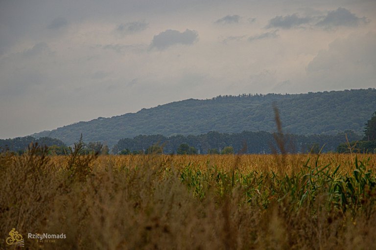
Зате по іншу сторону від ріки ми мали змогу насолоджуватися краєвидами Мошногірського кряжу. Це одне з природних див, яке привертає увагу як своєю красою, так і історією. Кряж простягається як дуга, яка вигнута на захід, довжина якої близько 28 кілометрів, від села Будище і до міста Сміла. Він є частиною наддніпровського комплексу гляціодислокаційних утворень. Все це стало результатом руху льодовика під час Дніпровського зледеніння, яке відбувалося приблизно від 250 до 100 тисяч років тому. Всередині дугоподібного Мошногірського кряжу розташоване болото Ірдинь, яке разом з річками Ірдинь та Тясмин є залишком древнього рукава річки Дніпро. І хоча саме болото знаходиться по ту сторону кряжу від нас, ми вже по дорозі почали будувати плани про те як відвідати ці всі чудові місця наступного разу.
 |
|---|
| Далі по дорозі |
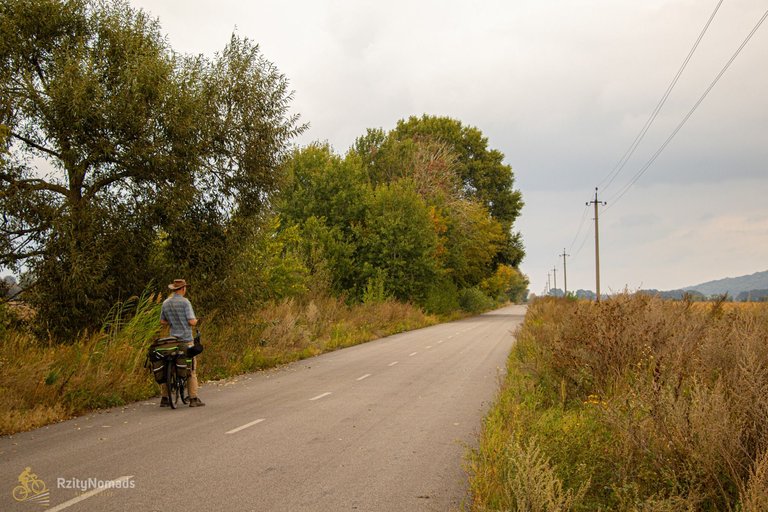
Невдовзі ми доїхали до краю села Мошни й звідти, проїхавши через село Лозівок, дісталися до місця, де річка Вільшанка впадає у річку Дніпро. Трохи тут перепочили, та по дамбі поїхали у напрямку села Хрещатик. Почалася вітряна погода, на яку мені на цій дамбі якось везе, хоча минулого разу я тут їхав коли було більш вітряно та ще й вночі. Тут ми особливо ніде не зупинялися і нічого не фотографували, оскільки поспішали засвітла потрапити в село Хрещатик, де потрібно було ще знайти місце для ночівлі.
 |
|---|
| Місцеві човни |
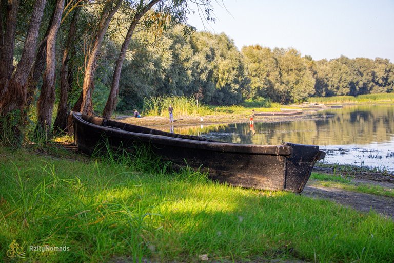
Коли ми дісталися села, то здавалося, що вітер ще більше посилився, тому ми ще витратили деякий час, щоб знайти затишне місце. А наступного дня була чудова сонячна погода. І я пройшовся трохи з фотоапаратом, пофотографував річку Рось (тут біля села вона впадає у річку Дніпро), човники, які розляглися на берегах, та ще трохи місцевих жителів природи. А потім були збори табору та шлях у напрямку міста Канів, а звідти я вже сам доїхав додому.
 |
|---|
| Осінніми дорогами |
Зі мною теж таке буває. Дивлюся на карту – і раптом виникає дике бажання відправитися невідомо куди. Якнайдалі від зручностей і благ цивілізації. І своїми очима побачити, які там краєвиди і що в тих краях взагалі відбувається. До лихоманки, до тремтіння. Але звідки в тебе це бажання з’явилося, нікому пояснити не можеш. Цікавість в чистому вигляді. Нічим не зрозуміле натхнення.
Харукі Муракамі, "1Q84"
 |
|---|
| Гора Дівиця |

The picturesque village of Mezhyrich is located where the Ros and Rosava rivers meet. The first memories of this village date back to the eighteenth century, but people lived in these places already in the late Paleolithic period. There are also findings from other times, such as the Trypillia, Zarubintsy, and Chernyakhov cultures, as well as from the period of Kievan Rus. However, our curiosity and the purpose of the trip was caused by the Paleolithic period and the fact that this village became world famous for the discovery of the dwelling of mammoth hunters. In 1965, a local resident Mykola Novytskyi was digging a cellar on the territory of his estate and during this activity he unearthed an incomprehensible bone, which he decided to show to a local school teacher, who reported it to the Institute of Zoology of the Ukrainian Academy of Sciences. This bone turned out to be the lower jaw of a mammoth. Later, within a few years, scientists conducted excavations here and found four dwellings made of mammoth bones.
|
|---|
| Reconstruction of the Mezhyrich parking lot in Japan (source) |
So, we planned to ride for three days, the first of which was to visit the area, or rather the Ros River valley, where these giants grazed in those days. I left very early and rode toward the village of Mezhyrich, where I planned to meet a friend who agreed to accompany me on this trip. The plan was to drive from the village along the right bank of the Ros River and explore the area. We had already been here in the summer, but we drove along the left bank. I knew the left bank well, because I often traveled that way when I was traveling to the city of Korsun. However, I had no idea what beautiful places there were if you drove closer to the river and went to the floodplain.
|
|---|
| Monument to the Victory of Labor |
We had to drive through the entire village, cross a bridge over the river, and thus get to the right bank of the river, which we did. After the bridge, we came to a monument called "Victory of Labor." The monument's plaque reads "Built by residents of the surrounding villages in honor of the drainage of the Ros River floodplain in 1914" and for those who know the history of these places, it reminds us of the catastrophic events that took place in these places more than a hundred years ago. In the 17th century, there was a great demand for potash (sodium carbonate), which required a large amount of wood to make, which led to the merciless deforestation. This led to an incredible development of erosion, which is why the longest ravine in Europe, the Khmilnyanskyi ravine, and the deepest, the Kostianetskyi ravine, are located near this place. In 1903, a huge mudflow swept through the Khmilnyansky ravine, demolishing part of the village of Khmilna and completely blocking the Ros River, which washed away the village of Mykhailivka. Until 1911, dredgers worked here to cut a new channel for the Ros. In general, reclamation work took place here until 1914.
|
|---|
| On the bridge near the village of Luka |
A little further, we turned off the road and rode along the right bank. But we didn't go very far - this bank is all sandy, and we had to roll our bikes most of the way. So we decided to walk in this mode to the nearest bridge, move to the left bank, ride part of the way there, and then return to the right bank. That's what we did, eventually reaching the place we needed, although not without incident. In this area, the map is not very accurate, so we came to a dead end, so to speak. There was no time to turn back, so we decided to push through a field of sunflowers, then through tall grass and some more wild boar. And then a little more, and we arrived at the planned campsite.
|
|---|
| Morning landscape |
I still haven't managed to cover the whole area, or any part of it. In the summer, we came here and climbed Mount Divytsia in the hope that we would take pictures of the local scenery, but everything on its top was so overgrown with acacia that it was impossible to see anything through the thickets. This time we were on the lower bank, and my idea was to take pictures of the morning mists. However, it rained at night, so there was no fog in the morning. So I took a picture of the cows grazing nearby - mammoths used to graze here, but now it's cows.
|
|---|
| Driving through the fields |
Next, our plan was to explore the Vilshanka River from the village of Starosilia to the point where it flows into the Dnipro. After a couple of dozen kilometers of roads through villages, we turned off to a field road that cycling along this river. The weather was frowning, it was raining occasionally, and we got into the mud in some places. You can't really see the river here because its banks are overgrown with various invasive species. Although from time to time, there were places where you could look at it, I didn't see any interesting scenes for myself.
|
|---|
| Moshnohirsky ridge |
But on the other side of the river, we were able to enjoy the views of the Moshnohirsk Ridge. This is one of the natural wonders that attracts attention both for its beauty and history. The ridge stretches like an arc curving to the west, about 28 kilometers long, from the village of Budyshche to the city of Smila. It is a part of the Naddniprovskyi complex of glacio-dislocation formations. All of this was the result of glacier movement during the Dnipro glaciation, which occurred approximately 250 to 100 thousand years ago. Inside the arcuate Moshnohirsk Ridge is the Irdyne Swamp, which, together with the Irdyne and Tiasmin Rivers, is a remnant of the ancient arm of the Dnipro River. And although the swamp itself is on the other side of the ridge from us, we started making plans to visit all these wonderful places on the way.
|
|---|
| Further along the road |
Soon we reached the edge of the village of Moshny and from there, passing through the village of Lozivok, we reached the place where the Vilshanka River flows into the Dnipro River. We rested here for a while, and then followed the dam in the direction of the village of Khreshchatyk. The weather started to get windy, which I am somehow lucky to have on this dam, although the last time I rode here it was windier and at night. We didn't stop anywhere here and didn't take any photos, as we were rushing to get to the village of Khreshchatyk before dawn, where we still had to find a place to spend the night.
|
|---|
| Local boats |
When we got to the village, it seemed that the wind had increased even more, so we spent some more time finding a cozy place. And the next day the weather was beautiful and sunny. I walked around a bit with my camera, took pictures of the Ros River (it flows into the Dnipro River near the village), the boats that lie on the banks, and some more local wildlife. And then there was a camp meeting and the road towards the city of Kaniv, and from there I drove home on my own.
|
|---|
| On autumn roads |
It happens to me too. I look at a map and suddenly have a wild desire to go somewhere unknown. As far away from the comforts and benefits of civilization as possible. And to see with my own eyes what kind of scenery there is and what is happening in those lands. It makes you feverish, it makes you shiver. But you can't explain to anyone where this desire came from. Curiosity in its purest form. Inexplicable inspiration.
Haruki Murakami, "1Q84"
|
|---|
| Mount Virgin |
Wow. That's a beautiful area to make a cycling tour!
Upvoted by the Cycling Community
Come join the Cycling Community and share your rides, bicycle, maintenance, news or any other cycling related content!
Supporting the Cycling Community
You can help the Cycling Community to support cyclists on Hive by delegating Hive Power or following our Curation Trail (via https://hive.vote: @hive177745)
You can select the Hive Power you like to delegate here:
25 - 50 - 100 -250 - 500
Yes, but sometimes it was something like that. 😆
Yay! 🤗
Your content has been boosted with Ecency Points, by @gidlark.
Use Ecency daily to boost your growth on platform!
Support Ecency
Vote for new Proposal
Delegate HP and earn more
Congratulations @rzity.nomad! You received a personal badge!
Wait until the end of Power Up Day to find out the size of your Power-Bee.
May the Hive Power be with you!
You can view your badges on your board and compare yourself to others in the Ranking
Check out our last posts:
Congratulations @rzity.nomad! You received a personal badge!
Participate in the next Power Up Day and try to power-up more HIVE to get a bigger Power-Bee.
May the Hive Power be with you!
You can view your badges on your board and compare yourself to others in the Ranking
Check out our last posts: