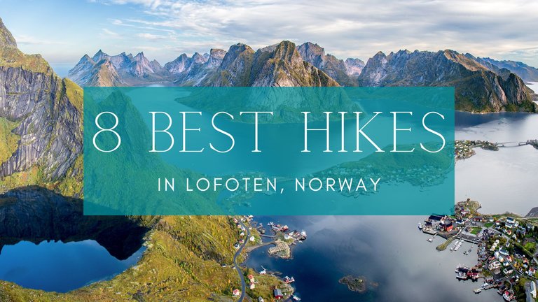
8 Best Hikes in Lofoten, Norway
Hello Hivers! Long time no see... again. Busy life is calling but I finally managed to write down my fave hikes we did in Lofoten in summer.
The Lofoten Islands are a paradise for hikers, mountaineers, and nature lovers. The picturesque hills and cliffs offer many options for hiking trails with many levels of difficulty for all kinds of visitors. Here are some of my favorites.
For each trek, you will find my subjective rating of difficulty, a map, the length of the route, and its elevation. Route length and elevation are always listed one way, i.e., if you want to go back the same route, you multiply the figures by two.
Ready to dive in?
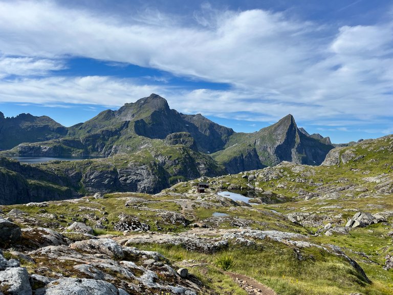
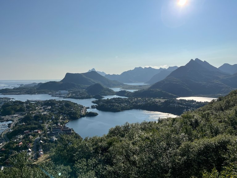
Svolværgeita
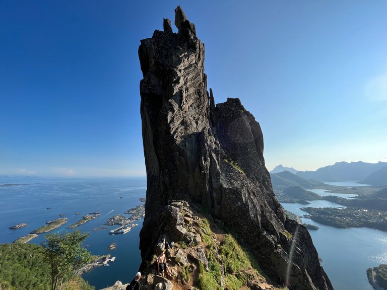
Difficulty: 5/5
Length: 0,7 km
Elevation: 306 m
Map: https://mapy.cz/s/ganupaluga
Svolværgeita is a rock formation towering above the town of Svolvær more or less in the middle of the Lofoten archipelago. It‘s famous for its extraordinary shape resembling two "fingers" and its beautiful view of the town, the sea, and other islands.
The climb starts at the paid parking lot (you can pay via the local parking app, instructions are always directly at the parking lots) and take on the journey. About 3/4 of the way up are made out of large stone steps. I hate this type of walkway with all my heart, and I always feel like I will leave my lungs there. I don’t know about your relationship toward this kind of path, but at least count on getting really sweaty.
The stone walkway then ends and after a little while, you will literally start climbing up. In some sections, there are ropes available to you, but most of the time, you don't need them - the rock is rugged and can be climbable without support. The route ends in the mountain saddle below the rock and offers a spectacular view. Just be careful as the slope is very steep on all sides and you definitely don’t want to fall off.
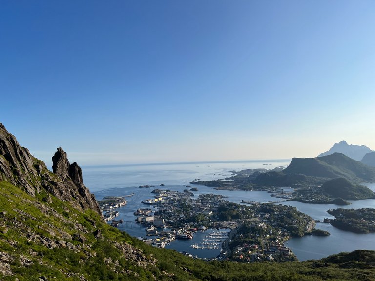
Djevelporten
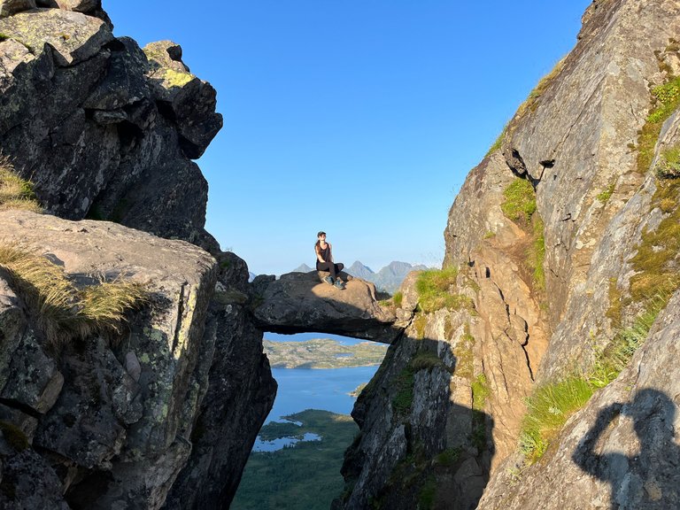
Difficulty: 3.5/5
Length: 1,4 km
Elevation: 433 m
Map: https://mapy.cz/s/narunapase
Djevelporten is located in the same massif as Svolværgeita. You go up the same stairs but take a left at the crossroads above them. The path will look like a normal mountain trail for a while before you get closer to the top, and then it turns back into stairs that will lead you to the gate.
The gate itself is a stone stuck flat between two rock masses. If you dare, you can climb it without too much difficulty. Just watch out for the sand on the rock, which can be quite slippery. It's quite a long fall down.
The reward at the top will be the beautiful views down to Svolvær and on the other side of the mountains towards the ocean. You can easily combine both trips to Djevelporten and Svolværgeita into one sightseeing trip. Find an outline of such a trip written on the map HERE.
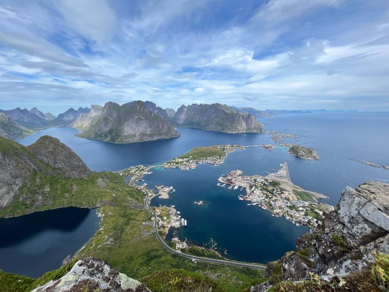
Reinebringen
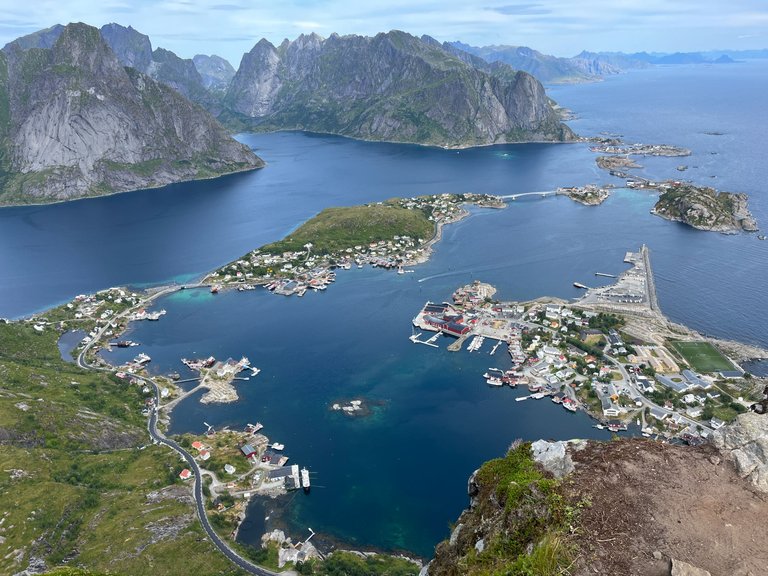
Difficulty: 4/5
Length: 2,4 km
Elevation: 452 m
Map: https://mapy.cz/s/govavulufo
Undoubtedly, the most popular and perhaps the most beautiful view of Lofoten comes from the hill above the fishing village called Reine. From the village, the peak looks absolutely inaccessible, but from the other side, it hides almost 2,000 stairs that take you to the top without needing much hiking skills.
But don't let the length of the route fool you: it's a tough hike. The stairs are very high, you will sweat a lot on them, and you'll get out of breath. Fortunately, spots are built out of stones to let you sit down and catch your breath.
The descent is paradoxically even worse, your knees and thights will really be suffering. However, the view is definitely worth it and without the climb up the Reinebringen it's like you haven’t even been to Lofoten. But many people know that and it shows – it’s the most crowded hike you’ll do there.
You can park in the centre of Reine by the gallery/infocentre parking lot. For this parking you pay 150 NOK (about 12€) for the whole day, and inside the building you will find free toilets, a café and a souvenir shop.
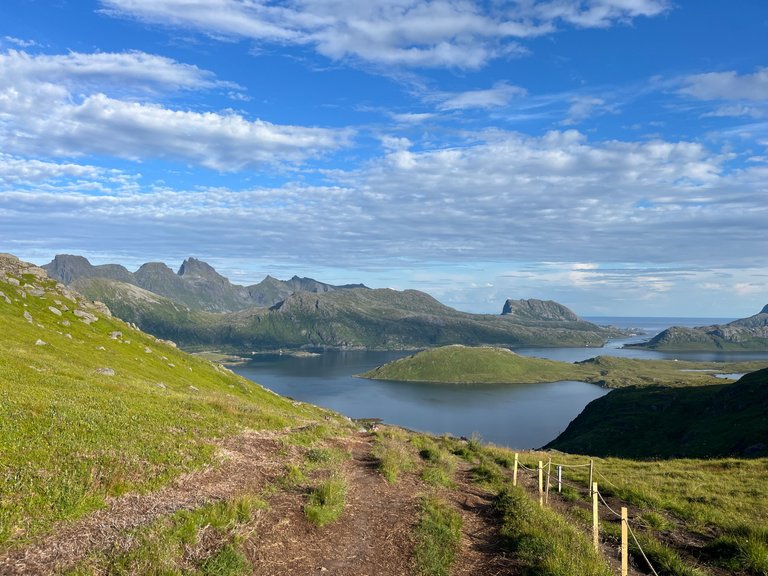
Mannen
Difficulty: 3.5/5
Length: 2,1 km
Elevation: 374 m
Map: https://mapy.cz/s/fosebufazo
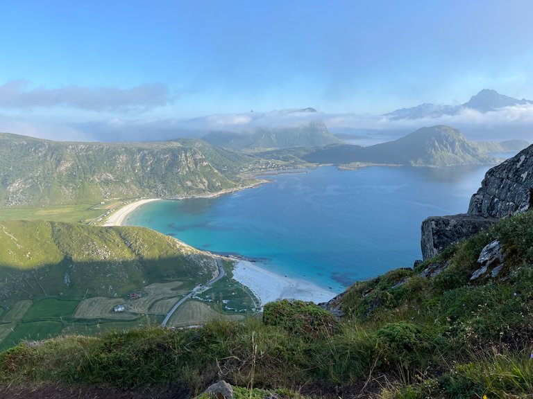
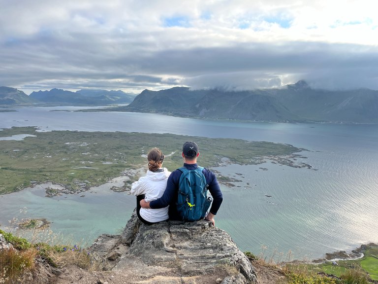
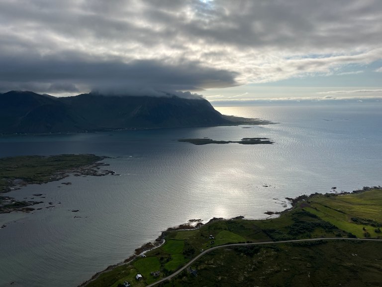
The massif of the Mannen and Veggen mountains divides two beautiful beaches: Uttakleiv and Haukland. The beaches are also popular as camping grounds, so you can combine a climb up Mannen with an overnight stay on one of them, just like we did.
The hike to the top is not difficult, it's just quite long and I don't recommend it for those who suffer from a fear of heights (but that's generally everywhere in Lofoten). The hike is beautiful and on the way from Haukland beach, you can admire beautiful green fields, high peaks, clear, turquoise water, and white sand on the beach. At the top, you can see also the other side, the Uttakleiv beach and its surroundings.
If you don't want to go back the same way, you can go down to Uttakleiv and walk along the path at the foot of the mountains, along the sea. We were already too late at the top to do this so I won’t tell you more about this circuit route. But it's definitely beautiful as it is beautiful everywhere in Lofoten. You can find the map of the circuit HERE.
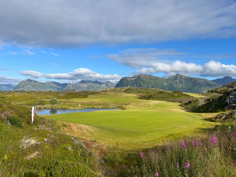
Hoven
Difficulty: 3/5
Length: 1,8 km
Elevation: 349 m
Map: https://mapy.cz/s/duguranuko
Yes, I admit, we picked this hike based on the name alone („Hoven“ somehow means „shit“ in my native language) and then looked to see if it was even worth it. 😁 And you know what? It is.
Hoven is a lonely peak in the north of the muddy island of Gimsøya and is relatively unknown. Yet it offers a relatively easy climb and a spectacular 360-degree views of the surrounding marshes, sea, mountains and islands, including the more distant archipelago of Vesteralen.
The route starts at the golf course and in many ways resembles the classic mountain hiking trails we are used to from Central Europe. At one point the trail is quite steep and can be slippery, so I recommend taking a side path through the blueberry bushes. Below Hoven you can even stay overnight in a campsite, it just doesn't have very nice reviews for the sanitary facilities (toilets and showers).
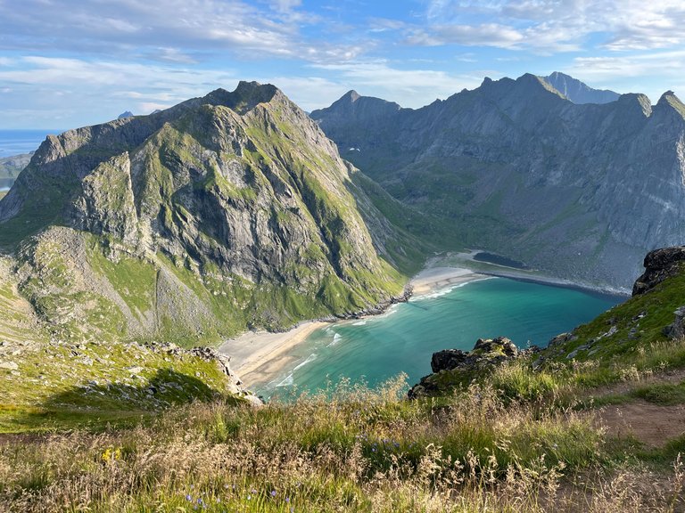
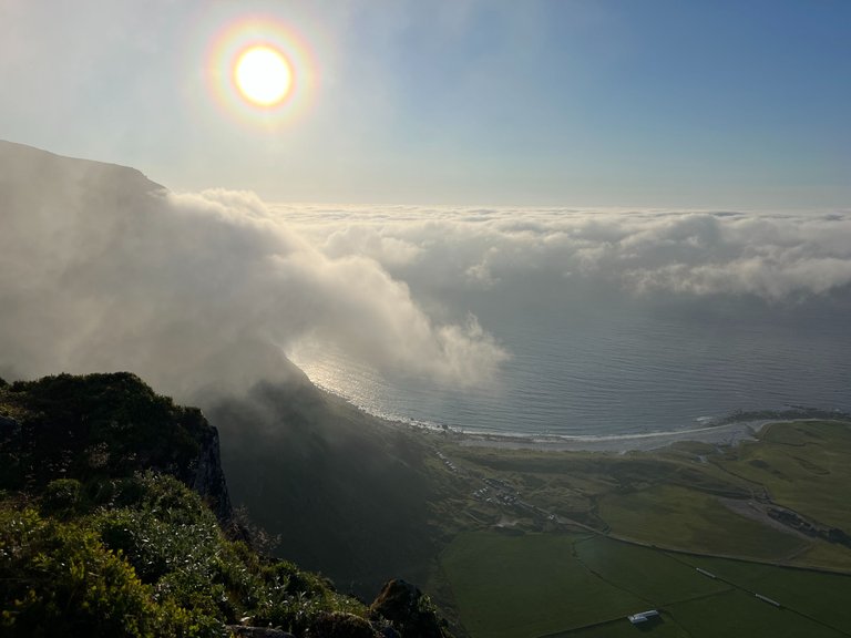
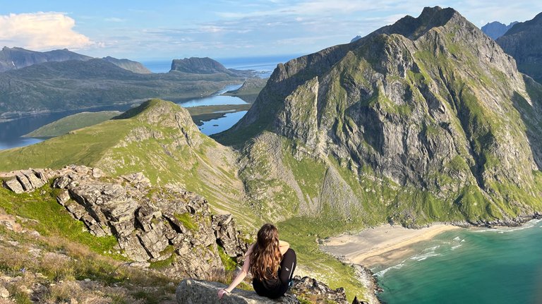
Ryten & Kvalvika
Difficulty: 4.5/5
Length: 5,7 km
Elevation: 1059 m
Map: https://mapy.cz/s/mehagetazo
One of the most popular trails in the Lofoten Islands leads to the top of Mount Ryten, from which you have a spectacular view of the famous Kvalvika beach. It was from here that you might have seen pictures on the internet of people hanging by their hands from a rock, seemingly over a precipice.
There are several routes to the beach, however, if you want to climb up Ryten, I recommend to choose the one I marked on the map. Especially if you decide to spend the night on the beach, you won't quite be in the mood for longer routes with a whole camping equipment on your back.
The hiking trail starts at the settlement with parking, toilets and drinking water. For parking you pay 100 NOK (about 8€) for the whole day or night. The trail follows a wooden walkway through the swamp and then turns into a "classic" hiking trail. You will climb up to the mountain pass and climb gently up the ridge until you reach the Kvalvika - Ryten crossroads. It is not well marked, but you can't get lost - the way up is well trodden.
On the way down, you turn right and follow the lakeside down to the beach. This is where the stretch that will give you a hard time begins: from here to the beach you will go a steep and sometimes muddy zigzag. And then you'll climb back up again. But the beach is definitely worth it - you can read more about it in my previous post HERE.
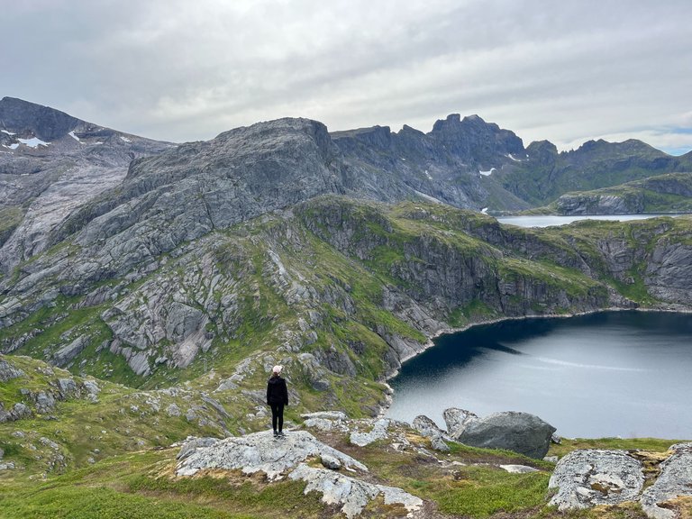
Hermannsdalstinden
Difficulty: 6/5 (crazy!)
Length: 10,2 km
Elevation: 2123 m
Map: https://mapy.cz/s/fobamemare
Hermannsdalstinden is the highest peak on Moskenesøy and one of the highest in the Lofoten Islands. It rises to over 1,000 metres above sea level (which is really a lot when you start at the sea level), and lies completely away from civilisation in the Lofoten National Park. It's so far away that you can't see it from almost anywhere.
The hike up is so challenging that most hikers split it into two days, which is what we wanted to do. In the end, however, several factors came together that prevented us from making the climb, and we made it about halfway, to the Munkebu hut. Therefore, I don't have more information on the actual climb up Hermannsdalstinden.
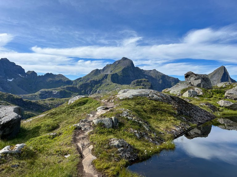
Munkebu
Difficulty: 5/5
Length: 5,1 km
Elevation: 611 m
Map: https://mapy.cz/s/lajozuhoto
Munkebu is a mountain hut about halfway to Hermannsdalstinden. We read from many blogs that you can stay in the hut or camp in its surroundings. So our plan was to walk to Munkebu, leave our backpacks with camping gear there, and just run up to Hermannsdalstinden with only water and snacks. Then return to Munkebu, spend the night there and in the morning walk back to Sørvagen, where the route starts. But the hut was closed, and there was also a camping ban in the area (probably new now).
As we were already tired and the weather was supposed to worsen in the evening, we chose to go back a little, where there were plenty of places to camp between the lakes (and where 3 tents were already pitched). But at night, it started pouring like crazy and the wind was so strong that we were worried about our tents and packed up and went down at 5am. So expect that it can get really wild in the mountains, give yourself more time than you think you'll need, and definitely don't underestimate the weather (including the wind).
But it's a beautiful route despite its difficulty, and even if you make it "only" to Munkebu, you'll be rewarded with gorgeous views of the beautiful mountains around you.
So those were my top hikes from the Lofoten Islands. Which one would you take?
For more travel content like this, feel free to follow me on PeakD, Liketu & Instagram.

Congratulations, your post has been added to Pinmapple! 🎉🥳🍍
Did you know you have your own profile map?
And every post has their own map too!
Want to have your post on the map too?
!discovery 38
This post was shared and voted inside the discord by the curators team of discovery-it
Join our Community and follow our Curation Trail
Discovery-it is also a Witness, vote for us here
Delegate to us for passive income. Check our 80% fee-back Program
Wow, what beautiful photographs ❤️ Thank you for sharing with us 😊
Thank you for your nice comment! Always a pleasure :)
Hiya, @livinguktaiwan here, just swinging by to let you know that this post made it into our Honorable Mentions in Travel Digest #2003.
Your post has been manually curated by the @pinmapple team. If you like what we're doing, please drop by to check out all the rest of today's great posts and consider supporting other authors like yourself and us so we can keep the project going!
Become part of our travel community:
Wow, thank you! :)
Awwweeee. I wish these places are just one ride away from here. Amazing and beautiful! Lucky you!
Thank you! Yes, I'm very lucky to have seen all of this!
Norway is my dream country! I will go back to this post once I visit Norway and have you been to the Trotlunga cliff?
Not yet! This was my first trip to Norway but I dare to say it wasn't the last :) and then I will definitely visit Trolltunga :)
Oh I see. I am excited to see your next blog and trolltunga is a fantastic cliff. (I didn't notice that I misspelt it in the first comment)
It looks so stunning there, like an other world! I hope I can make it there some day!
highly recommended! Those were some of the most gorgeous views I've ever seen.
Ještě že ty soutěžní fotky nemusím vybírat já, ale nechávám to na soutěžících. Opravdu nevím, kterou bych vybral.
!LUV
za použití #aroundtheworld
@itsmikyhere, @bucipuci(2/5) sent LUV. | connect | community | HiveWiki | NFT | <>< daily
! help(no space) to get help on Hive. InfoCongratulations @itsmikyhere! You have completed the following achievement on the Hive blockchain And have been rewarded with New badge(s)
Your next target is to reach 23000 upvotes.
You can view your badges on your board and compare yourself to others in the Ranking
If you no longer want to receive notifications, reply to this comment with the word
STOPCheck out our last posts:
https://peakd.com/hive-140169/@lordbutterfly/help-us-decide-the-winner-of-vibes-week-34-community-poll
Pls vote for me. it’s my first time to be on top 15 list 🙏🙏🙏🙏 sorry for the inconvenience. Sincere apologies
@bigsteff
I hope I find favor in your sight
https://www.reddit.com/r/natureporn/comments/1nhlult/8_best_natural_views_in_lofoten_norway/
This post has been shared on Reddit by @arasiko through the HivePosh initiative.